Home
|
Africa
|
Britannia
|
Germania
|
Iberia
|
Illyria
|
Italia
|
Language
|
References
|©1997-2004 B M Walker
La Rochelle
Pons, Guimps, Cahors
The Roman roads leading south east from Pons is clearly marked on maps leaving Pons by the east gate. At Avy it forked with the northern branch heading for Guimps and finally Cahors and the southern branch continuing to Bordeaux. The road to Guimps is visible throughout its length and follows an almost perfectly straight alignment from Avy to Guimps.
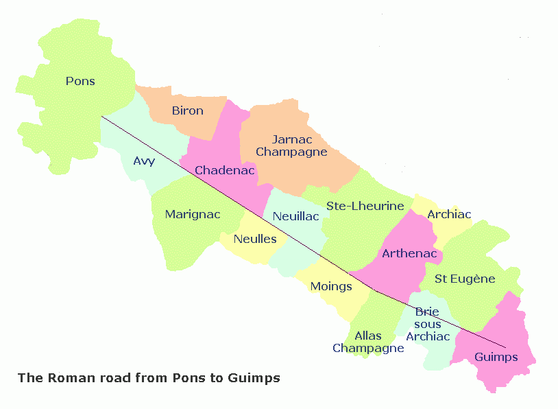 Pons to Avy
Mediolanum Santoniensis (Saintes) will have been founded during the Augustan reorganisation after the conquest as a "show" capital with added advantage being of a port on a tidal river. Saintes was also the terminal for one of the first roads to be built (according to Strabo) which crossed the Auvergne and linked Lyon to the coast in upper Aquitaine.
Leaving Pons, the road lies under the D142 on a straight alignment for the centre of Avy where the church probably stands on the metalling. Leaving Avy, it bifurcates with the branch to Guimps diverging to the right. When working on the extension of the airport extensive remains of circular structures were uncovered with pottery and other artefacts. These date from the middle La Tène (third to fourth century B.C.E.). A large circular enclosure with Gaulish pottery was found and dated to the first century C.E. Several apparently ritual deposits have been found on various sits around the village. These also date in part from the La Tène B. All in all the area seems to have had extensive and early occupation with the ritual sites indicating intense religious activity. The parish is bisected by the Roman road and obviously predates it.Avy to Neuillac
Leaving Avy the road marks the boundary between parishes with late empire foundation names. The modern road at St-Richer leis on the roman road and this alignment is continued past the site of old mines on the left at les Grègoires , along a field track joining a short stretch of modern road at Chaudron. Marignac reaching down to the river Treffle has preserved one Gaulish hamlet name, Usseau from Ucel "high", perched appropriately on the highest spur overlooking the river valley. Beyond the parishes bordering the road to the north, Germanic names begin to appear. A Roman milestone was found in 1863 in a cemetery of the Middle Ages at Chadenac with the inscription,In the first case the milestone would have stood, before being moved to the cemetery, at Chaudron where the road crosses the small stream that flows down from the vicinity of Chadenac church. If Chaudron can be traced to Lat. caldarium (steam bath) then the milestone would have stood outside the way station.
| MODERN NAME | OLD NAME | NOTES |
| Allas | Alacius | Gaulish personal name |
| Archiac | Archius acum | Gaulish personal name |
| Arthenac | Artamo acum | Gaulish personal name |
| Avy | Avus acum | Gallish personal name |
| Biron | Birus onem | Gaulish personal name |
| Brie | Briga | Gaulish ""hill"" |
| Chadenac | Capitonus acum | Latin personal name |
| Chaudron | Lat. calderia | steam room |
| Guimps | A Guintum | German name ""Windo"" |
| Jarnac | Agarnus acum | German personal name |
| Marignac | Marinius acum | Gaulish personal name |
| Moings | ? | ? river name |
| Neuillac | Novellus acum | Latin new place |
| Neulles | Niga villar | German ""niga"" new |
| Pons | Pons | Latin ""bridge"" |
| Usseau | Uxello | Gaulish ""uxel"" high |
The most interesting surviving name on this section is Brie, Gaulish "briga" eminence. Although briga was used by the Romans when coining names for their new foundations in the first century, the fact that the word here stands alone indicates that it is a genuine local name. Two other names have been lost to us, those underlying St Eugène and Ste-Lherius. Moing is unexplained and Dauzat postulates a river name without suggesting a derivation. If he is right we may have here the original name of the Treffle.
Brie to Guimps