Home
|
Africa
|Britannia
|
Germania
|
Iberia
|
Illyria
|
Italia
|
Language
|
References
|©1997-2004 B M Walker
La Rochelle
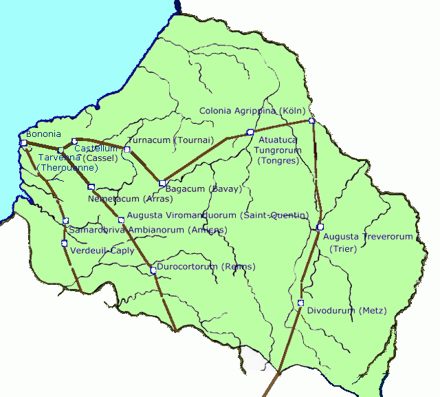
Earliest Roman roads in Gallia Belgica

 One can also leave Lyons and the countries upstream on the left and, passing
through Poenia, cross the Rhone or Lake Lemanis (Lake Geneva)
to reach the plains of the Helveti.
One can also leave Lyons and the countries upstream on the left and, passing
through Poenia, cross the Rhone or Lake Lemanis (Lake Geneva)
to reach the plains of the Helveti.
From there, using a pass over the Jura, one can reach the lands of the Sequani and the Ligoni where the road splits into a branch leading to the Rhine and another leading to the Ocean." In this text "the Ocean" refers almost certainly to the Channel coast and the North Sea
There seem to have been two parallel routes to the sea, one passing through Senlis, Vendeuil-Caply, Amiens to Boulogne and the other reaching Boulogne by Cassel (or Therouanne), Arras, Saint-Quentin and Reims. An additional major route may have linked Boulogne, Tournai, Tongres and Köln but this route is based on archaeological evidence only and is nowhere attested in ancient texts.
The planners will have given priority to military needs. For example the route to the Channel coast passes from secure bases like Reims in the country of Roman allies through the sites of winter camps noted by Caesar. It takes no account of major civilian centres such as Beauvais and Soissons.
The road to the Rhine gives a date for the foundation of Augusta Treverorum (Trier) where the bridge over the Mosel must have been open before the reorganisation of Gaul was completed in 13 BCE.